Category:Lawrence L. Knoebel Covered Bridge
Jump to navigation
Jump to search
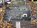
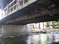
English: Lawrence L. Knoebel Covered Bridge, originally built near Benton, Pennsylvania over West Creek in 1875. In 1936-1937 it was moved to cross the South Branch of Roaring Creek between Cleveland Township in Columbia County, Pennsylvania and Ralpho Township in Northumberland County, Pennsylvania, in the United States. It is one of the entrances to the camping area for Knoebels Amusement Resort.
|
This is a category about a place or building that is listed on the National Register of Historic Places in the United States of America. Its reference number is 79002309. |
| Object location | | View all coordinates using: OpenStreetMap |
|---|
covered bridge in Columbia County, Pennsylvania  | |||||
| Upload media | |||||
| Instance of | |||||
|---|---|---|---|---|---|
| Location | Columbia County, Pennsylvania | ||||
| Crosses | |||||
| Heritage designation |
| ||||
 | |||||
Media in category "Lawrence L. Knoebel Covered Bridge"
The following 16 files are in this category, out of 16 total.
-
 Lawrence L. Knoebel Covered Bridge 1.JPG 3,648 × 2,736; 3.29 MB
-
 Lawrence L. Knoebel Covered Bridge 10.JPG 3,648 × 2,736; 2.06 MB
-
 Lawrence L. Knoebel Covered Bridge 11.JPG 3,648 × 2,736; 3.61 MB
-
 Lawrence L. Knoebel Covered Bridge 12.JPG 3,648 × 2,736; 3.36 MB
-
 Lawrence L. Knoebel Covered Bridge 13.JPG 3,648 × 2,736; 2.49 MB
-
 Lawrence L. Knoebel Covered Bridge 14.JPG 3,648 × 2,736; 3.42 MB
-
 Lawrence L. Knoebel Covered Bridge 15.JPG 3,648 × 2,736; 3.89 MB
-
 Lawrence L. Knoebel Covered Bridge 16.JPG 3,648 × 2,736; 2.57 MB
-
 Lawrence L. Knoebel Covered Bridge 2.JPG 3,648 × 2,736; 4.06 MB
-
 Lawrence L. Knoebel Covered Bridge 3.jpg 4,416 × 2,656; 2.35 MB
-
 Lawrence L. Knoebel Covered Bridge 4.JPG 2,736 × 3,648; 2.16 MB
-
 Lawrence L. Knoebel Covered Bridge 5.JPG 2,736 × 3,648; 2.67 MB
-
 Lawrence L. Knoebel Covered Bridge 6.JPG 3,648 × 2,736; 4.3 MB
-
 Lawrence L. Knoebel Covered Bridge 7.JPG 2,736 × 3,648; 3.49 MB
-
 Lawrence L. Knoebel Covered Bridge 8.JPG 3,648 × 2,736; 3.18 MB
-
 Lawrence L. Knoebel Covered Bridge 9.JPG 3,648 × 2,736; 2.21 MB


Categories:
- National Register of Historic Places in Columbia County, Pennsylvania
- National Register of Historic Places in Northumberland County, Pennsylvania
- Covered bridges in Pennsylvania
- Knoebels
- Bridges in Columbia County, Pennsylvania
- Bridges in Northumberland County, Pennsylvania
- Bridges on the National Register of Historic Places in Pennsylvania
- South Branch Roaring Creek
- Covered bridges on the National Register of Historic Places in Pennsylvania